 |
| Finding Your Coordinates |
Longitude
latitude
Latitude is used together with longitude to specify the precise location of features on the surface of the earth.
Altitude
 |
| Coordinates on earth surface |
Methods to find out your location coordinates
Now days with the advancement in technology there are various ways with the help of which we can find out the coordinates of our location on the earth surface.
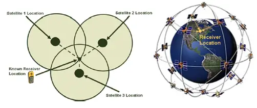
Using GPS – Global Positioning System
Finding your Sample Site Coordinate using GPS
 |
| Using Global Positioning System (GPS) |
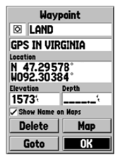
you can store the waypoint in the receiver. You will need to save your sample site location
as a waypoint; this is useful as you can later use this point as a navigation guide and it also acts as a digital copy of your coordinate, which can be, used alternative non‐paper back up.
1) In order to save your location you need to first make sure you are standing at your
sample site. Next navigate to the ‘map’ screen using the ‘page’ button.
2) In the top right hand side of this screen there should be a box titled ‘accuracy’
you need to write the ‘accuracy’ value down on your data sheet (value in meters). THIIS VALUE MUST BE BELOW 5 METRES.
3) Once you have an accuracy value at or below 5 meters you can make an accurate
waypoint. Press and hold the ‘Enter’ button on the map screen until a ‘waypoint’ screen appears. Once in this screen you can save and edit your waypoint coordinate information.
4) First, before you edit your waypoint, you must write the location value onto your
data sheet. This value must be given in decimal degrees (will appear on you screen
as a number followed by a ‘°’ symbol).
5) In the first large box you can edit the name of your waypoint the name of the waypoint
is often set as a number by default, you should change this to a name that is easily distinguishable as your sample site (for example use GLWW). Using the ‘rocker’ key highlight this box and click ‘Enter’, you can now use the ‘rocker’ to select letters using a pop up keypad, click ‘ok’ once you have selected all your desired letters. You can then repeat this same method in the comment box.
6) After you have edited your waypoint data select ‘ok’ using the ‘rocker’ key and
press ‘enter’. This will save the waypoint coordinates into the internal memory of
the GPS unit.
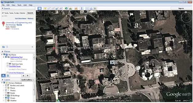
Using Google earth
1. Open the google earth software – free to download from the google and then enter your location information in the search box
2. Zoom in the Google earth as much as possible until you find the location exactly as required.
3. Move the mouse cursor over the desired location as shown here in the picture with A.
4. Then from the status bar read the coordinates of the desired location
Like Us on Facebook!
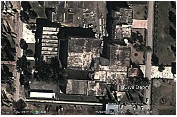
The coordinates of the Civil Department as shown here is;
330 46’ 00.13’’ N and 720 49’ 30.73’’ E and elevation is 1644 ft.
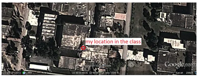
My location approx. on the day the assignment was given has coordinates of
Subscribe Us on YouTube!
330 46’00.66’’ N 720 49’ 29.68’’ E and elevation of 1646 ft from ground and as I was on the first floor it could be approximately 1646 ft + 11 ft = 1657 ft.